
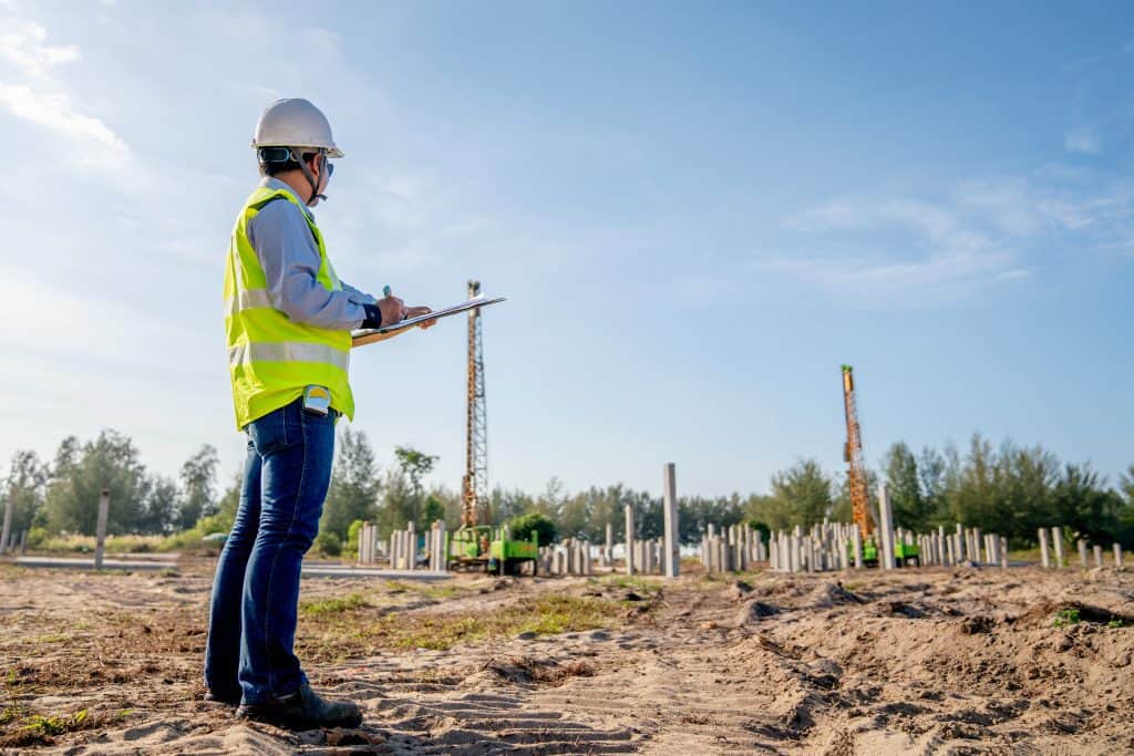
It is the responsibility of both civil engineers and surveyors to ensure landscaping, walkways, parking lots, roads, and buildings are adequately constructed in compliance with all building regulations whenever a building project is being executed. Although the jobs of surveyors and civil engineers seem to be similar, each actually has a unique role that is crucial to accomplishing the task. Civil Engineer vs Surveyor – let’s dive in and discuss each!
WHAT DOES A CIVIL ENGINEER DO?
The job of a civil engineer is to design building projects and supervise the construction of water systems, bridges, dams, tunnels, airports, buildings, and roads. By relying on a surveyor’s report, they are able to estimate how long a project would run and how much it would cost, as well as figure out possible barriers or risks.
The job of a civil engineer also entails identifying and testing construction materials for specific projects, including testing soils to know the type of foundation that is appropriate for a building project. Prior to construction activity, civil engineers also provide government agencies and the public at large with their plans.
WHAT DOES A SURVEYOR DO?
Properties have to be surveyed whenever they are purchased or sold. It is surveyors who identify suitable building sites and eco-friendly areas and specify boundaries for property lines. Surveyors determine how deep the foundation of a building should be, and the exact place where common areas, sidewalks, roads, and facilities should be located. In addition, they write reports, draw maps, research property records, and measure angles, directions, and distances. Before construction begins, they also try to resolve all possible problems with structure by closely working with engineers and other building experts.
ACADEMIC QUALIFICATIONS FOR SURVEYORS AND CIVIL ENGINEERS
The minimum educational requirement for surveyors is usually a bachelor’s degree, particularly in civil engineering or surveying technology, and they can endorse legal property documents only if they are licensed. It is the licensed surveyors who oversee the activities of unlicensed survey technicians. Since they have to provide exact details about various aspects of properties, surveyors need to have excellent written and oral skills. Moreover, they have to be good at managing time and solving problems, and must be able to pay attention to details. Considering that it is crucial to promptly complete construction projects, it is the job of a surveyor to provide adequate and reliable information in advance.
For civil engineers, a bachelor’s degree is the minimum educational requirement, though to serve as a manager in firms, they usually need to have a master’s degree or Ph.D. Licensing is also important for civil engineers, whose critical-thinking and math skills must be superior as well. They must possess the ability to deal with potential issues prior to the commencement of construction, since they usually work on airports and other big projects covering several buildings, including their environments and infrastructure. For them to interact with the public and share their ideas with other professionals, civil engineers also need to have excellent communication skills.
How Are Projects Executed by Surveyors and Civil Engineers?
Apart from being a complex field, civil engineering is older than every other engineering discipline except military engineering. Although it is usually affiliated with public works, civil engineering is not just about that. It refers to any form of engineering in which infrastructure, like pipelines, bridges, and canals, is constructed on the surface of the environment.
Surveys are of great importance, given the direct, and often significant, impact that civil engineering has on the environment. They help to ensure the safety of the structure, protect the environment from adverse effects, and guarantee the success of the entire project.
Thus, this leads to the question: what does surveying mean in civil engineering? Surveying is a vital aspect of the development process of a project. Below explains why surveying has so much importance.
There are different types of construction in which engineers can specialize; for example, they can specialize in structural, mechanical or architectural structure. Each type of engineer has a special role in a construction project, or is trained to work on certain types of building projects. Notwithstanding, engineers, regardless of their area of specialty, are required to work in tandem with surveyors.
Using the important information that they get from the surveyor, architects and engineers are able to draw up a list of relevant site-specific details that need to be considered for a project. The civil engineer can obtain information from the surveyor regarding the exact location of the bridge footings, which will allow them to know the amount of weight that the bridge can carry, as well as the appropriate strategies required to construct it.
Before construction is done, a surveyor will always be needed to survey the site so that the engineers can know the best spot where the structure can be erected. Additionally, the shape of the land must be taken into consideration in an engineer’s drawings, as it will be wrong for the engineer to assume that the land has a completely flat shape and construction should be done right away. The surveyor gives the engineer information regarding the topography, and assists them in formulating plans to address the flaws in the land.
In most cases, the surveyor also participates in the project’s blueprint development phase, where they provide the construction crew with details like boundary information and GPS coordinates.
By enforcing a complete adherence to the engineer’s plan and carrying out regular checks to see that the structure is rightly positioned on the property, the surveyor keeps track of the construction process to ensure every aspect of the project is executed as planned by the engineers.
Nowadays, surveying has been made easy with the use of drones. In particular, the advantages of utilizing drones for surveys include:
1. Gathering Valid Data for Proposals
Accurate surveys play a vital role when it comes to completing engineering proposals. The general public is usually required to approve public works, either by electing lawmakers who have an interest in accomplishing certain projects, or via direct vote. Thus, any improvements that the public considers dangerous would be resisted.
The future of a project heavily depends on the collection of accurate data. It is possible to create 3D simulations using the right drone surveys. For instance, the surrounding environment could suffer from erosion, or poor water flows when a new road is constructed without conducting surveys.
Lawmakers can convincingly defend their proposals in the public as soon as accurate drone surveys have been conducted, giving the public the opportunity to make more informed decisions. Before lawmakers throw their weight behind a project, data collected through surveys can help them know whether the project is safe or not.
2. Examining Areas with High Risk, like Bridges and Other Similar Structures
Without endangering the lives of personnel, it is possible to complete bridge surveys, including any other form of high-risk survey, with the help of drones. The fact that it may be difficult or unsafe for a person to get into areas that a drone can easily enter shows that a conventional survey is naturally more dangerous than a drone bridge inspection. With drones, more thorough surveys can be conducted to improve the overall safety of a bridge, since they can easily fly around the bridge, as well as around other complicated structures.
A large number of bridges in the U.S., including several structures like dams, canals, and other civil infrastructure, are in a dilapidated condition and could collapse anytime soon due to lack of regular inspection. Because of the difficulty in inspecting dams and other similar infrastructure, there may be issues with such structures that have not yet been detected.
Aside from flying very close to the ground, drones can hover. What this means is that they can be used to inspect seemingly inaccessible areas, making it possible for projects to be safely completed.
3. Settling Legal Conflicts between Public and Private Property
As far as properties are concerned, issues may arise that culminate in a serious disagreement. For instance, issues often emerge between private ownership and public property after the commencement of civil engineering projects. Particularly, boundary surveys may be useful for resolving any border issues pertaining to the land under development. Drones can be used to provide information on where public lands begin and private land ends, which not only helps to prevent the use of prominent areas, but also to avoid overpriced acquisitions.
Without doubt, at present, the safest and fastest way of conducting regular land surveys is through the use of drones; it is usually much faster to deploy them, even though they may not be as fast as airplanes. In this way, legal issues can be averted before they morph into serious problems, thus ensuring that crucial public works problems don’t get prolonged, and convincing citizens that the land being developed is strictly public property.
There is a close connection between civil engineering and surveying, and drone technology can assist civil engineers in completing their projects in many ways. The surrounding environment of the target area needs to be surveyed and scanned, regardless of whether it is a private or public project. With the help of UAV technology and other technologies like LiDAR scanning, low-cost and highly accurate surveys can be conducted for different types of engineering works.
What Is the Role of Surveying in Civil Engineering?
All civil engineering projects are planned, built, and maintained based on surveys. To know the exact boundaries of the target area, as well as to ensure the safety of the buildings or structures erected on it, there is a need to perform a full-scale survey of the area. Surveyors also improve the efficiency of the proposed structures and safeguard the surrounding natural environment by providing suitable designs for the construction of the infrastructure.
What Kinds of Surveying Does Civil Engineering Require?
Geodetic surveying and plane surveying are the major types of civil engineering surveys. In geodetic surveying, which is only used for very large projects, the earth is considered as a sphere. Government agencies usually make use of geodetic surveys to carry out major infrastructural projects, like pipelines and canals, within their territories. On the other hand, in plane surveying, the area is viewed as a level geometric plane, as the surveyor ignores the earth’s curvature. This type of surveying is most suitable for projects that are not more than 250 km2.

The type of survey is determined by the focus. As a case in point, a surveyor would usually perform both water (hydrographic) and land (topographical) surveys if they are asked to provide surveys for a dam. After the dam has been constructed, the surveyor may also reexamine it to make sure that it is safe, within the map boundaries, and corresponds with the plans. Technically, this is known as “as-built” survey.
Why Do Civil Engineers Need Topographic Surveying?
Topographic survey is most commonly utilized in civil engineering. It is the specific qualities of the land that are considered by topographic (land) surveyors. In other words, topographic surveys are concerned with the nature of the land (i.e., whether it is grassy, forested, or rocky, etc.), measuring relative elevations, and collecting data regarding the angles and distance between key points. They may also include data on human constructions like power lines and roads, as well as on natural features like rivers and hills. A land or property surveyor may also make maps by using topographic surveys.
Why Should Civil Engineers Use As-Built Surveying?
Even after construction has been completed, the services of a civil engineer are still required. In order to confirm whether the data have been accurately used, a new survey is needed for each project once completed. As an example, an as-built survey is performed to check whether the positions of the final project, including other specifications, correspond with the measurements earlier provided. To make sure that structures are still safe and in their proper position, as well as to ascertain their technical performance, it is essential to constantly survey them.